Enregistrez gratuitement cette image
en 800 pixels pour usage maquette
(click droit, Enregistrer l'image sous...)
|
|
Réf : T01438
Thème :
Terre vue de l'espace - Volcans (181 images)
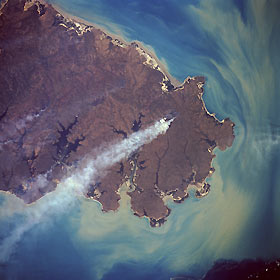
Titre : Melville Island, Northern Territory, Australia August 1992
Description : (La description de cette image n'existe qu'en anglais)
Melville Island, a sparsely populated island with fewer than one person per 9 square miles (23 square kilometers), lies off the northwest coast of Northern Territory. The island covers approximately 2400 square miles (6200 square kilometers) and is separated from the mainland by the Clarence Strait. A large part of the island (this photograph shows the eastern two-thirds) consists of sandy soil and mangrove jungles. Although Melville Island is considered part of north-central Australia that is influenced by the summer monsoons, the dry season—sometimes lasting 7 or 8 months—is much longer than the wet season. Fires caused by land clearing activities or by recent lightning strikes are the source of one large smoke pall and some smaller ones. The sediment pattern in the Van Diemen Gulf and Dundas Strait, south and southeast, respectively, shows the surface water current distribution and dispersion at the time this photograph was taken. A dense sediment plume hugs the southeast coast of the island.
|
|

